![]()
The Seljuk Han of Anatolia
SELJUK TRADE ROUTES
back to the Roads and Routes page
|
|
|
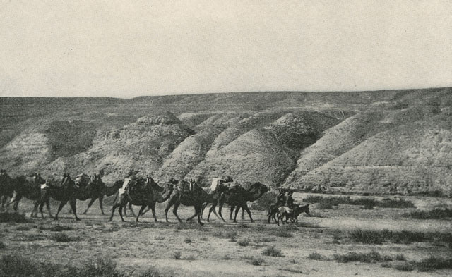
The dog may bark, but the caravan moves on. (It ürür, kervan yürür)
|
This well-known Middle Eastern proverb is believed to be Turkish in origin. Even though the dogs barked loudly and did their best to hinder the advance of the caravan, their bark could not stop the caravan from reaching the end of its journey. And so it is with history and progress, which moved ahead in Anatolia, no matter what the challenges or criticism, with caravans and hans playing a central role in this endeavor. Hans were the pathways of trade, communication, development, and cultural exchange, and their stones speak the history of the land.
Roads have crossed Anatolia since the beginning of time, as it is a natural land bridge between Asia and Europe. It has always been a magnet for trade, as this rich land had much to offer in natural resources and agricultural products. Anatolia upon the arrival of the Seljuks in 1071 was ripe for the development of commerce, and the Seljuk sultans placed special importance on the development of trade. In this context, the Seljuks conquered important ports on the Black Sea and the Mediterranean in the 13th century: Antalya (1207), Sinop (1214), Alanya (1221) and Suğdak (1225). The conquest of these ports stimulated the development of trade in Anatolia. The Seljuks signed agreements with foreign trade agencies, such as the Venetians, the Genoese and the Latin Kingdom of Cyprus. They introduced an insurance system for merchandise and founded hans on different trade routes.
Although they continued to use Roman and Byzantine period roads, the Seljuks dusted them off, repaired many of them and created additional roads to suit their transport needs. As such, they created the foundations of the transit infrastructure of modern-day Turkey. As the Seljuk Empire grew, so did a need to create an even more intricate web of roads connecting the heartland with the trade opportunities from the east and west. New branch roads became necessary to link all of the cities of the empire. Controlling, safeguarding and encouraging this trade potential was of utmost importance for the emerging Seljuk state. In addition, trade established a bridge between the Christian and Muslim populations of Turkey at this time. However, it was the establishment of hans, which were mostly donated by the members of Seljuk dynasty and affluent commanders, which was probably the most significant step in the promotion of trade.
The network of trade routes developed extensively after the arrival of the Seljuks in Anatolia. Roads were built to service the major commercial cities of the time, to wit:
- Persia and Central Asia to the east (Tabriz)
- Syria and Iraq to the south (Aleppo, Baghdad)
- The Mediterranean coast ports (Antalya, Ayas)
- The Black Sea ports (Samsun, Sinop and Trabzon)
- Istanbul (under Byzantine control until 1453)
Main roads radiated from core cities, much like modern airport hubs. A caravan coming from the east, for example, could arrive at Sivas or Tokat, and then decide whether it would branch north to the Black Sea, west to Ankara and Istanbul, or south to the Long Road to Konya, and from there west to the Aegean coast or south to the Mediterranean coast. This web of routes crisscrossing Anatolia linked cities both large and small and offered infinite route options depending on the markets for the goods carried. Information concerning these roads comes from a variety of sources, such as the Seljuk-era journals of Ibn Bibi and Qadi Muhyiddin Ibn Abduzzahir and the travel journals of Westerners such as Rubruck, Clavijo, Pegalotti, Taeschner and Sarre. The important work done by D. French on Roman roads, the research of Hild and Restle on Byzantine roads, and by M.K. Özergin on Seljuk roads is also invaluable. The contemporary groundwork research of Prof. Dr. Osman Eravşar is investigating many of the clues left in these texts.
“The light rises from the East”, states the Turkish poet Cemil Meriç. So let us begin our journey there.
ROADS COMING WEST FROM IRAN
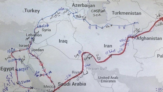
Let us imagine we are a caravan originating in the East and desiring to come to Anatolia to trade. The camels are loaded and ready to set out. The starting city would have been Tabriz in Iran, which was an end point for many of the roads coming from farther east along the so-called “Silk Road”. The goods transported from the Far East and Iran were destined mainly for Istanbul and then on to Europe, figuratively linking the pavilions of Peking to the palaces of Paris. These goods were also traded in the bazaars of the Seljuk Empire. Caravans leaving Tabriz went either west into Anatolia or south to Syria, from where they could continue on to the desert peninsula.
Roads from Tabriz south to Syria:
Tabriz-Van-Aleppo Road (Tabriz-Van-Ahlat-Diyarbakir-Aleppo)
The majority of the caravans heading south down to Syria passed through the cities of Van, Ahlat and Diyarbakir, which were important cities in the Seljuk era.
Tabriz-Ani-Aleppo Road
An alternate route led south through the city of Ani. The Armenian city of Ani was an important hub, especially for caravans coming from the Caucasus. The roads coming from Tabriz in the east and from the Caucasus from the north intersected at the city of Ani and then the road split in different directions. One road headed west to Anatolia and another went south to Syria (Raqqa and Aleppo) following the route of Van, Ahlat, Bitlis, Erzen, Silvan, Diyarbakir, Harran and Suruç. Özergin determined the layout of this road based on the pilgrimage travel journal of the Iranian Nasir Hüsrev (1035-42), who stated that it became a main road as a result of the political and financial development of the 11th century, but that it later lost its function and became a branch road. An important building on this road was the El Bağrur Han, near Harran, which was an early Islamic era building substantially repaired in the Seljuk period.
|
Route taken by Nasir Hüsrev in 1035-42. |
Routes from Tabriz west into Anatolia:
Tabriz - Erzurum Route
Our camels in all probability headed for the city of Erzurum to do their trading with the Seljuk Empire. If the caravans headed west into Anatolia, the first destination of the caravans would be the city of Erzurum.
The Tabriz - Erzurum Route was one of the main caravan routes of the Seljuk period. Voyagers from Tabriz to Anatolia crossed Nakhichevan by following the Aras River valley. From Tabriz the route ran either south of the Ararat chain along the upper Euphrates (Murat) valley, or north of the Ararat chain along the Aras valley, before continuing towards Erzurum. The most important road continuing east was the road which led to Erzurum by passing through Doğubeyazit and the Iğdir Savannah. Özergin noted the names of the stops along this route based on historical sources. These include: Iğdir, Sahensa, Mersengen, Surmeli, Veli Baba, Aras River, Aini, Çoban Bridge, Hasankale, and Erzurum. We can imagine that hans existed in these spots or along the road between them, but most have disappeared, except for the magnificent Iğdir Şerafeddın Ejder Han. When the Spanish traveler Ruy González de Clavijo passed through this region in the early 15th century on his way to the court of Tamerlane, he stayed overnight in a castle he called Egida (Iğdir), located at the foot of Mount Ararat. Clavijo describes it as being built upon a rock and ruled by a woman, whose husband had been killed by Tamerlane. The exact location of this castle has not been determined, but his visit indicates that this was a well-travelled route. William of Rubruck, the Flemish missionary who wrote one of the most important masterpieces of medieval travel literature (along with those of Marco Polo and Ibn Battuta), took this route during his voyage to the east to visit the Great Mongol Khan at Karakorum in 1254.
ROADS IN THE HEARTLAND OF ANATOLIA
Erzurum-Sivas Route
Our caravan has reached Erzurum and now wants to head into the heartland of Anatolia to trade. From Erzurum, the caravans would head to Sivas. At this point, the caravan had two options: it could head north up to the Black Sea (Tabriz-Erzurum-Sivas-Tokat-Samsun-Sinop) or south to the Mediterranean Sea via Kayseri and Konya (Tabriz-Sivas-Kayseri-Konya-the coast).
The Erzurum-Sivas caravan route was a route which dated prior to the Roman period and most of its stops were marked on the Tabula Petungeriana, the famous map of the road network of the Roman Empire (the 13th century parchment copy made by a monk in Colmar in 1265 is considered based on the original, now lost). This road was heavily-traveled during the Seljuk period. It was used by caravans as well as by armies, and the famous battle of Kösedağ, where the Seljuks lost to the Mongols in 1243, occurred near to this road. There were certainly hans along this segment, but they are lost or in ruins today (Ilica, Cibice, Mughisar, Aksar, Grabeco, Zara, Dodurga, Isfahani-Kemaleddin Ahmet bin Rabat).
It is interesting to note that the number of hans in eastern Anatolia is sparse, despite the fact that Erzurum and Sivas were principal trading hubs for the empire. It is believed that there were once many hans here but they have not survived. Current research on hans is focusing on this area to uncover their traces.
Erzurum-Trabzon Route
From Erzurum, instead of heading onto Sivas, our caravan could have headed north to the Byzantine city of Trebizond on the Black Sea, where the merchandise would have been loaded onto boats and sent to Constantinople. An alternative route from Erzurum continued west, to Erzincan, and then to Sivas from where the Black Sea was reached at Sinop or Samsun. Trade went mostly east to west, but some went the opposite way. There was a substantial north to south trade in furs, honey, and slaves from southern Russia, most of which passed through Trebizond (see below, “The North-South Routes”.
Sivas-Mediterranean Road (Sivas-Ayas on the coast)
Our caravan from Tabriz has now arrived at Sivas. This city presented a wagon wheel of routes into the heartland of Anatolia and beyond.
One route led down to the Mediterranean coast and the port of Ayas (modern day Yumurtalik, site of the Incirlik Air Base) on the bay of Iskenderun. Ayas was an important port and the backbone of trade in the Mediterranean region before the conquest of Alanya. Goods here were traded with many Mediterranean ports in the hands of Europeans, such as the Lusignans of Cyprus. As a result, Ayaz became an international trade port and an exit point out of Anatolia during times of disruption, especially during the Crusade era.
Sivas-Malatya Road
The road continued on from the center of Sivas center to the south, crossing over the Eğri Bridge on the Kizilirmak River and on towards Ulaş to the southeast. The Tuzla and Tecer hans were on this road. The locations of the Tuzla and Tecer Hans are known, but there are no remains of these buildings. The road arrived at the Alaca Han (substantially rebuilt in the Ottoman period) and then connected to Malatya via the Hekim Han.
Sivas-Kayseri Route
The other option of our caravan would be to head into the Seljuk “Triangle”, formed by Sivas, Kayseri and Konya. From Sivas, our camels would plod on to the heartland of the Empire: the capital of Konya and beyond.
Sivas was an important city in the Seljuk era, and this was one of the busiest routes in Seljuk period, as it connected two of the most vital cities of the Seljuk Empire: Kayseri and Konya. The road was in use before the Seljuks. Roman and Byzantine armies passed over it, and the Romans built baths along it. This road is the location of one of the most important hans ever built, the Kayseri Sultan Tuzhisar Han.
Although this was a heavily-trafficked road, there are few traces of hans today. According to historic sources, the road originated in Sivas and reached the Latif Han, but no traces of this han have been found, despite the fact that it was mentioned by Pegalotti and Ibni Bibi and must have been substantial. Another stop along this route was the village of Çubuk. Although it was claimed that there was a han here, no trace of it remains. Ibni Bibi stated that welcoming ceremonies were held for statesmen in Çubuk and that these ceremonies were held in portable kiosks erected for the purpose, which leads us to believe that there was no permanent han here. Ibni Bibi also mentions the Lala Han, but it, too, has not been located. The next station after the Lala Han was the Kayseri (Tuzhisar) Sultan Han which was called the “Gavsera del Soldano” (the Sultan’s Caravanserai) by Pegalotti. The last station before Kayseri after this han was the Kagi Han, which was also known as the Çirgalan Han.
From Kayseri, the caravan could head south to Malatya, Diyarbakir, Van, Mesopotamia and Iran, or more certainly, onto the capital of the Seljuks at Konya.
Kayseri-Konya Route: “The Long Road”
Konya calls! The Kayseri-Aksaray-Konya axis, known as the "Ulu Yol", or "Grand Road", is the most famous Seljuk road of all. It led from Kayseri to Aksaray, passing through deep valleys and following an uphill and downhill route. After Aksaray, the road crossed the flat Anatolian plains around Obruk and arrived finally at Konya.
This was an ancient route. In the Roman period, Kayseri was at the heart of the commercial network, just as it had been since the Assyrian Trade Colonies period. Ibni Hurdazbih (Ibn Khordadbeh), the 9th century Persian geographer, was the author of The Book of Roads and Kingdoms (Kitab al Masalik w’al Mamalik), the earliest surviving Arabic book of administrative geography. He traveled along the Kayseri-Konya route prior to the Seljuk period and noted the names of Roman and Byzantine castles along it. His book allows us to understand that this road was already a well-traveled one 300 years before the arrival of the Turks in Anatolia.
As can be expected for such a highly-traveled road, there were many hans built along it, many of which are still standing and others whose traces have disappeared. The road continued west from Kayseri until it arrived at a han around the Sultan Marsh. This unspecified han was described by the travelers who visited the region at the beginning of the 20th century as ruined. The road split in two after the han, with one branch leading to Niğde in the southwest direction and the other to Aksaray in the northwest direction. It is believed there was another han, called the Sunnetli Han, after the anonymous han located in the Sultan Marsh outside of Kayseri, but it location has not been determined.
The next stop in the direction of Aksaray was the Avanos Sari Han, followed by the Alay Han built by the Seljuk Sultan Izzeddin Keykavus. Then on to the Oresin Han, which is known as the earliest dated han in Anatolia. The road continued on to the Ağzikara Han and then on to Aksaray, another important city in the Seljuk era. The road went west from Aksaray and the first stop on this road was the Ak Han, of which only a small wall section remains. After this, travelers would encounter one of the most spectacular hans ever built: the Aksaray Sultan Han. The station after it was the Kiliç Arslan Han, which is mentioned in sources but whose location has not yet been determined. The next station was the Obruk Han located next to a sinkhole lake. Ibni Bibi states that welcoming ceremonies for Seljuk Sultans were held here and portable kiosks were erected around the han. Ibni Bibi also mentions a han after the Obruk Han named the Kaymaz Han, but its location is unknown. After Obruk and the trek across the flat Konya Plain, the caravan would arrive at the Zazadin Han, a major han. The last station before Konya was the Horozlu Han, now on the outskirts of Konya.
ALL ROADS LEAD TO (AND FROM) KONYA: THE HUB OF THE EMPIRE
Konya was the capital of the Seljuk Empire, so all the roads were designed to reach this city. No matter where you were in Anatolia, your ultimate goal was to reach the big city of Konya. Roads to the south, north and west radiated to and from Konya to ensure the commercial needs of the Empire.
Our caravan which originally started in Tabriz has now arrived in Konya and sold his goods, refilled his bags with Turkish goods and perhaps would turn around and head back to Iran with his Turkish goods to sell in the markets of the East. Perhaps he would carry on west or south from Konya to continue trading, but in all likelihood, Seljuk merchants would step in and transport the goods from both the Eastern and Anatolian markets to the various points of the Empire. Imported and Turkish goods were distributed by a series of roads in many directions around the kingdom.
WEST FROM KONYA:
Konya-Beyşehir-Isparta-Denizli Route: Goods moving west from Konya
Caravans leaving Konya and heading westwards would have taken the road to Lake Beyşehir, site of the famous Kubadabad Palace built by Sultan Alaeddin Keykubad. This relatively short stretch of road has quite a few hans still standing along it. Once again, there are references to hans which existed along this road, now lost, such as the Köle Hasan Han and the Yunuslar Hans. The first han along this road was the Dibidelik Han (Hoca Cihan Han), followed by the Altinapa Han, the Kizilören Han, which had a derbent outbuilding near it, and the Kuruçeşme Han. Another han, the Yunuslar Han, and a 5-arched bridge, now lost, were also located along this stretch of road.
The caravan would arrive at the glimmering turquoise waters of Lake Beyşehir, a relatively important spot in the 13th century due to the Kubadabad Palace. From Beyşehir the caravan could decide to head either towards the Mediterranean in the south or Denizli to the west. A caravan road existed on both sides of this beautiful lake.
The branch following the eastern rim of the lake down from the northern edge of the lake and arrived at Şarkikaraağaç, site of a ruined han in the nearby village of Yassibel, whose inscription may be the one exhibited in the Yalvaç Museum. Further down this side of the lake is the Atabey Ertokuş Han, which was located at the crossroads of the roads coming from Istanbul and those coming from the Mediterranean coast and Konya.
The road continued around the bottom (southern) edge of the lakes and led up to the Giyaseddin Keyhüsrev II Han at Eğirdir. The road continued west from Eğirdir directly west to Isparta, at which point it bifurcated south and north. The road going to the south led down to Antalya and the road leading west arrived at Denizli.
This Denizli route was an important caravan road in the Seljuk Period and the west branch led to the Aegean port of Izmir. The last caravanserai on this road is the Ak Han near Denizli. The western branch road arrived at the Pinarbaşi Han, now in ruins, and then came the Çardak Han and the Ak Han. It crossed the bridge near the Ak Han, and finally ended at Denizli. Denizli was one of the frontier cities in the Aegean region during the Seljuk period. Because of this, there were no more hans built west of Denizli.
SOUTH FROM KONYA: there were several ways to reach the Mediterranean region from Konya:
Konya-Beyşehir-Alanya Route
The other direction of caravans arriving at Beyşehir was to head south to the Mediterranean coast to the ports of Antalya and Alanya. This road is one of spectacular beauty and passes through mountainous terrain. It crossed over a bridge noted by Sarre and whose inscription and stones were subsequently found. It continued on south with the Yenice (recently discovered), Derebucak Tol and Ortapayam (at the top of a steep slope) Hans along this road. The Tol Han #2 and the Rodar Han (now lost) were also on this road. The final station before arriving at the coast was the Alara Han. The first station for caravans continuing on to Alanya was the Şarafsa Han. Known as the "High Road", this road was built by Alaeddin Keykubad I to ensure communication between Alanya and Konya. It ran westward along the Mediterranean coast from Antalya to Alanya.
Beyşehir-Köprülü Canyon Road
Another route departing from Beyşehir to the Mediterranean region was the Manavgat road, which passed through difficult slopes and deep valleys of the Köprülü Canyon with many switchbacks. The Burma and Kargi Hans were located on this road. After the Kargi Han, the road split and continued to the port of Alanya to the east and to the port of Antalya to the west.
An alternate route south: the Konya-Şeydişehir-Alanya Route
An alternate road to go down to the Mediterranean Coast from Konya bypassed Beyşehir entirely and went directly south to the city of Seydişehir. If you take a modern intercity bus from Konya to go on holiday to Antalya, you will travel along this exact same route. This road was in use since ancient times and was renewed with the conquest of Alanya. The road originated in the Meram District to the southeast of Konya, and continued along the Hatunsaray Valley. The hans located along the gorges of this mountainous region have all disappeared (Kavak, Yikik, Girvat). The road united at Şeydişehir with the road coming from Beyşehir and continued south as described above. Another road reached Gündoğmuş and the Alara Castle, again via Seydişehir.
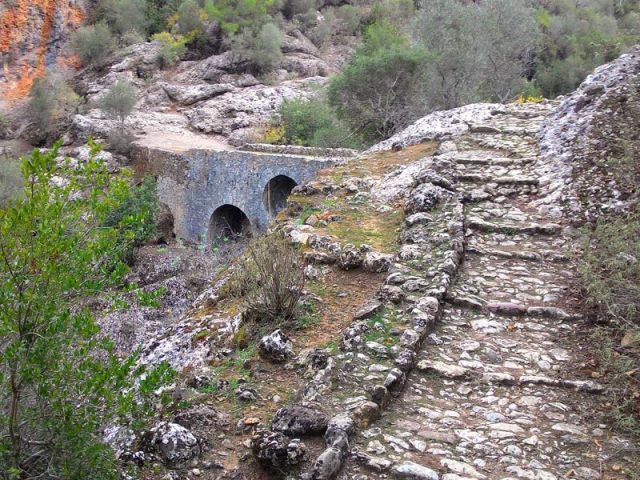
The first station after Şeydişehir was the ruined Seljuk han in the village of Yenice, whose location has been recently identified. The Ali Bridge, dating from the Roman period, was also on this road before arriving at the Alara Han.
|
The Ali Bridge near Alanya, used by the Seljuks |
Konya-Ayas (Yumurtalik) Road
Another historical road went south from Central Anatolia to the Çukurova (Cilician) Plain and the Mediterranean Region. The road went from Konya to Karapinar to Ereğli to Ivriz to the coast. The Persian geographer Hurdazbih traveled this road in the 9th century and stated that the security of the road was provided by a Byzantine castle located near Karapinar. The road headed from Ereğli south towards Ivriz (now site of a dam) and passed over the Ak Bridge built by the Seljuks and arrived in the Cilician region. The road passed through the lands controlled by the Armenian Kingdom of Cilicia, climbed through the Taurus mountains and arrived first at Tarsus (Mersin), and then to the port of Ayas, located to the west of the Bay of Iskenderun (present day Yumurtalik). This route, a difficult one due to the fact that it crossed both mountains and swamplands, fell out of favor after the conquest of Alanya and Antalya. However, it still maintained its importance and continued in use for a long period by both merchants and pilgrims on the way to the Holy Land.
NORTH FROM KONYA: the Konya-Ankara Route
North of Konya was the Seljuk city of Ankara. Ankara may be the capital of the Republic of Turkey today, but during the Seljuk era, it was a relatively minor city. It was the site of the infamous battle for the throne between Izzeddin Keykavus I (?-1220) and his brother Alaeddin Keykubad. Researchers think there may be several lost hans along this road (Dolgu, Mogan), but the ones still standing are the Horozlu and Zivarik Hans. Caravans headed northwest from Konya and the first station on the Konya-Ankara route was the Horozlu Han. The Zivarik Han was located next, although this may be a post-Seljuk construction.
THE NORTH-SOUTH ROADS
Konya may have been the capital and draw of the empire, but not all the wheels of commerce churned in its direction. The Black Sea and markets to the north beckoned as well. The northern cities of Tokat, Amasya and Sinop saw development as trade centers at the end of the 13th century with increased activity after the Mongol conquest in 1243.
Down from the Black Sea into the Heartland: the Samsun-Sivas-Malatya Route
The Danishmendids, the first Turks in the Pontic region, built a castle in the port of Samsun, which they shared with the Byzantines. Trade increased and the caravan roads leading south were developed.
The terrain south of Black Sea port of Samsun is mountainous and rugged. The first destination south of Samsun was the Çakalli Han. The road followed the Deronos valley and continued to the Merzifon connection and crossed the Kurt Bridge and arrived at the Seljuk city of Amasya. The road continued along the Yeşilirmak River which flowed through the city and led east to Tokat. Before reaching Tokat, the caravans would arrive at the Ezinepazar Han, site of a historic famous bazaar and a gathering point for merchants. The road continued along the Kazovasi Valley and reached Turhal. At this point the caravans could continue east to Tokat or head west towards Zile.
Tokat became an important nexus of caravan routes in the Seljuk period. The road heading to Tokat reached the Pazar Hatun Han, a substantial han located next to a bridge. A bit further on, the road split again into a series of branch roads through the area. The road branching to the north from the main road arrived at Tokat by passing through rugged and gorgeous terrain, curving over mountains before reaching the Ibipse, Tahtoba and Çiftlik Camlibel Hans. After the Çiftlik Camlibel Han, the road flattened out near Yildizeli, and from here it arrived at Sivas by crossing over the stunning Seljuk Yildizeli and Kesik Bridges. From Sivas, the road could link west to Konya as described above, or southeast down to Malatya and Iraq.
Sinop-Amasya Road
Another route south from the Black Sea originated in Sinop, which became the center of political and commercial activities once it was conquered by the Seljuks in 1214 and became the gateway to the Black Sea for the Seljuks. Sinop was ruled successively by the Seljuk, Pervaneids (c. 1263) and Candarid (c. 1322) Beyliks. During this period, the Seljuks were in constant competition with nearby Christian Trebizon (Trabzon) for control of the city, despite that both became Mongol vassals from the mid 13th century onwards. Muslim-Christian relations played an important part in trade. Sinop was the gateway of Anatolia to the northern shores of the Black Sea and vice-versa. Although, as described above, there is a clear caravan road south from Samsun via the Çakalli Han, Ezinepazar Han, Hatun Han, Tahtoba Han and the Çiftlik Han to Sivas, or dividing south of Amasya to head south-west to Kayseri via the Çekereksu Han, Çinçinli Han and the Sultan Han, there is only one road which was located to bring traffic from Sinop to the main road south from Samsun. There is only one han near Sinop, the Durağan Han. The road departing from Sinop arrived at the Durağan Han, at which point it bifurcated and led east to Amasya through Vezirköprü and Merzifon.
Unye on the Black Sea-Niksar-Tokat Route
Another route came down from the port of Unye on the Black Sea to Niksar. The road led south from Niksar and crossed over mountains to arrive at the town of Avlunlar. One of the two inscriptions on the wall of a mosque in this town belongs to a han. The road continued to the south after the han, whose location was determined at the entrance of the town. It arrived at Tokat by crossing over a bridge spanning the Yeşilirmak River near Comana Pontica (Gümenek).
Zile - Aksaray Route
If at Turhal the caravan decided to head west to Zile instead of east to Tokat, it would have continued south from Zile and to other regions through Aksaray. The road continued over the bridge to the south of Zile and reached the Çekereksu Bridge and Han. The road continued south to the Karamağara hot springs and then continued west in the direction of Kirşehir. The Camalik Han, now lost, was located along this stretch of road. The road passed in front of the Kesikköprü Han after Kirşehir and followed the Kizilirmak River and over a Seljuk period bridge before arriving to the town of Ortahisar. The last stop on this road was Aksaray.
Routes south to Syria and Mesopotamia: the Kayseri-Elbistan-Aleppo Route
From the Sivas and Kayseri connection, routes led south to the Mesopotamian region through Malatya and Elbistan, which was the road taken by the Mamluk Baybars when he invaded Anatolia in 1256. The first destination after exiting Kayseri was the Ispile Han, of which only a few ruined sections remain. The next station was the Karatay Han. The road followed the river beds and passed through rugged terrain before arriving at the Yabanlu Bazaar, the trade fair market forum since the days of the Assyrian Trade Colonies Period. The road continued on, passing by the Kuru Han 2, the Çoğul and the Afşin Hans. The road arrived at the Kizil Han, now in ruins. The next station was the Kuru Han. The road continued towards the Hurman Castle from here. The next station on the road heading towards Elbistan was the Kuru Han 2. There was also a mountain pass (derbent) located near this han. The road arrived at the Çoğul Han, and then bifurcated. One branch led to Elbistan and the other to Afşin. Elbistan was a frontier town which served as a gateway to the region. Because of its key location, the Seljuks had taken certain precautions to both protect the city and to control access to it. One of these measures was the construction of a mountain pass fort (derbent) in the settlement formerly known as Akça Derbent, and this fort also served as a stopping place as well. The next station was the Nurhak Zille Han. The road then split towards the east, connecting to Malatya through Nurhak, where the road split again towards the south to reach Aleppo via Gaziantep.
A note on trade routes after the Mongol conquest of 1243:
The Mongol conquest of Anatolia in 1243 changed the dynamics of trade. As the Mongols moved into Iran in the 1220s and into Anatolia in the 1240s, centers shifted and trade was rerouted based on changing interests. Tabriz in western Iran soon became an important center since it was in a position to absorb goods from the Caucasus, the Eurasian steppes, and the Silk Road. The Black Sea trade, Trebizond in particular, remained important throughout the 13th and 14th centuries.
The need now arose for a han network in northeastern Anatolia, a region where the Seljuks never built much. However, it is not certain how much the Mongols invested in trade, if any, and cared to build hans as did the Seljuks.
Only a limited number of hans were added to the network after 1300, and then mostly in the northeastern corner of Anatolia, and none are dated past 1300 with any certainty. The surviving late 13th century structures in Anatolia suggest that there was more attention paid to the routes leading from Iran into Anatolia. A few hans were built along the road from Erzurum into Khorasan can be attributed to this period, such as the Serafeddin Ejder and Köprüköy Hans, based on stylistic evidence and some references in sources, but no inscriptions have been preserved to confirm their construction dates.
In a 14th century manual for merchants, the Florentine broker Francesco Pegolotti (d. after 1347) listed toll stations along the route from Ayas to Tabriz, based on the accounts of other traders who used this route, since Pegolotti himself never traveled there. Easily recognizable stops along the way, where a toll had to be paid, were Ayas (“Lalazzo di Erminia”), Sultan Han Kayseri (“Gavsera des Soldano”), Sivas (“Salvastro”), Erzincan (“Arzinga”), Erzurum (“Arzerone”) and Tabriz (“Torisi”.) He also spoke of a “Polerbech” which could be the han at Koprukoy. It would seem evident that if they charged tolls along these roads, then they must have charged to stay in the hans built along them.
On the roads Pegolotti described, caravans became sparser east of Sivas, even though these sections of the trade network were heavily used in the 13th and early 14th centuries. They must have existed, and for this reason, this region is where the new research on hans is being done today.
It is likely that many of the 13th century hans remained in use after the Mongol invasion and beyond, as can be seen by the glowing report on the Karatay Han by Qadi Muhyiddin Ibn Abduzzahir, who traveled with Baibars during his campaign in 1277, even though the Mongol conquest changed the dynamics of trade. Though trade continued into the 14th century, the Mongol realm was in a deep fiscal crisis by this time, in part due to a loss of control over various regions, including Anatolia. With the arrival of the Ottomans on the scene, the entire pattern of trade shifted towards supplying the capitals of Bursa, Edirne and Istanbul.
©2001-2026, Katharine Branning; All Rights Reserved.