![]()
The Seljuk Han of Anatolia
TAHTOBA HAN
Not much remains of this han, located in a picturesque village in the hills of the Tokat region, and which is believed to have been one of the seven hans built by Mahperi Hatun in this area.
|
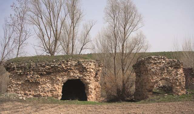
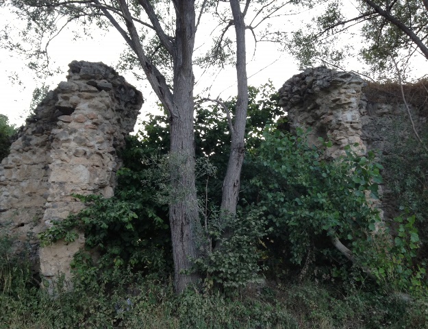
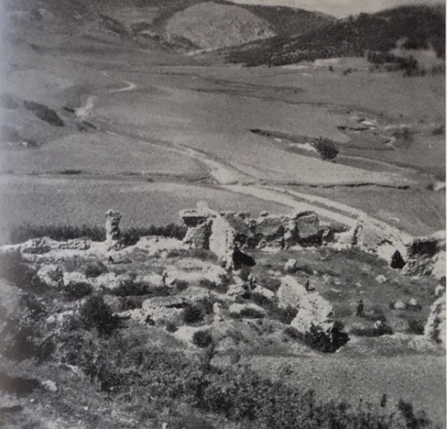
Eravşar, 2017. p. 276; photo I. Dıvarcı |
|
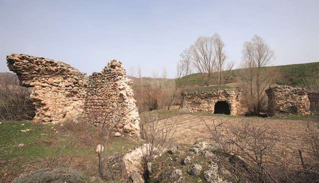
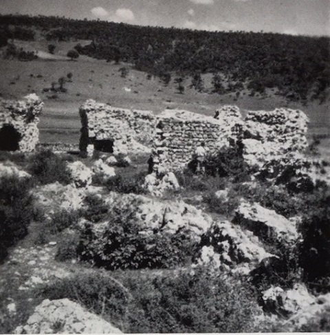
Eravşar, 2017. p. 272; photo I. Dıvarcı |
|
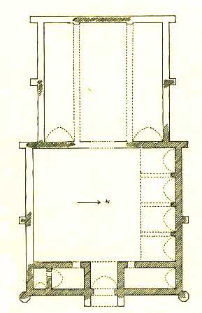
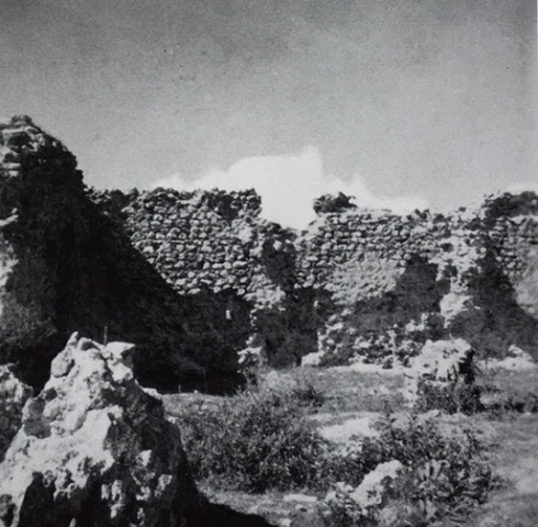
plan drawn by Erdmann |
|
|
|
|
DISTRICT
60 TOKAT
LOCATION
40.220928, 36.468655
The Tahtoba Han is located on the Sivas-Tokat Road, 3 km north of Artova and
17 miles south of Tokat, in the village of Tahtoba. It is located on the Tokat-Sivas
caravan route, which has been in in use for a long time. The road coming from
the direction of Pazar to Tokat unites here with the road coming from Tokat and
continues towards Sivas.
The Samsun-Sivas road reached the Pazar Hatun Han. From there, a branch road led into Tokat, and another branch road south passed through rugged terrain, curving over mountains before reaching the Ibibse, Tahtoba and Çiftlik-Camlibel Hans. After the Çiftlik-Camlibel Han, it led to the Yeni Han in Yildizeli, which is an Ilhanid period building. The road connected with a flat and straight road coming from Tokat after the Yeni Han. From here, it arrived at Sivas by crossing over the Yildizeli and Kesik Bridges.
NAMES
The han is named after the village in which it is located. The name of the village is a combination of two words: ‘taht’, which means “crown” or “throne” and “oba”, which means “a settlement in a mountainous place or a highland”. Indeed, the setting perched on the green Tokat hills is a throne of nature in its finest.
The Jesuit priest and archeologist Père Jerphanion is the only one to have provided information about the han. He marked the village as an Armenian settlement on his famous series of four maps drawn of the region.
DATE
1238-46
PATRON AND CONSTRUCTION DATE
There is no inscription on or around the building. The dating of the han has generally been related to the notion that the Seljuk hans in this region were built by Mahperi Hunat Hatun, wife of Alaeddin Keykubad I and mother of Giyaseddin Keyhüsrev II. There is no proof to this theory that she built several hans in this area, but based on the only han with an inscription, the Pazar Hatun Han, which was considered built between 1238 and 1246, it is highly likely that she was the patron of this group of hans. The han most similar to this one, in regard to its plan and size, is the Pazar Hatun Han, again an argument for her patronage.
BUILDING TYPE
Covered section with an open courtyard (COC)
Covered section smaller than courtyard
Covered section with 3 naves (a central aisle and 2 aisles on each side running
perpendicular to the back wall)
DESCRIPTION
The entrance of the han faces east. It is classed among the group of hans with a building plan comprising a covered section and an open courtyard with service areas.
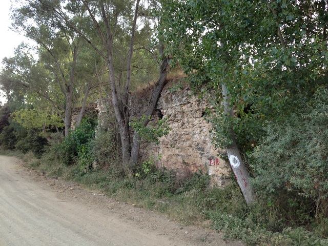
The han is in ruins, but an analysis of the remaining solid wall segments of the covered section can give a good idea of the plan of the han. The han appears to have the same plan as the Pazar Hatun Han.
Courtyard:
The courtyard is in better condition than the covered section. The entrance crown door, the rooms on both sides of it, the greater part of the north wall, the central section of the south wall, as well as the west wall of the covered section, are still standing.
The crown door protrudes from the front wall and has a pointed arch. The section after the entrance in the direction of the courtyard is shaped like an iwan and is covered with a pointed vault. There is a room on each side of this iwan, covered with pointed vaults in the north-south direction. The entrances to these rooms are from the west side of the courtyard.
Covered section:
The covered section was divided into three naves with two support lines. There are four square piers in each support bearing lines of pointed arch line continuing in the east-west direction towards the rear wall. Traces on the rear wall indicated that the covered section was also covered with pointed vaults in the east-west direction. These traces also indicate that the middle nave was higher and wider than the side naves.
EXTERIOR
Support towers are located in the corners of the courtyard and in the middle of the north-south wall. In view of the large size of the courtyard, there were probably arcades on one or several sides.
Support towers can also be seen in the corners of the west section of the han.
BUILDING MATERIALS
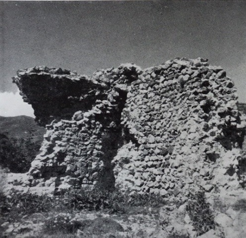
A nearby quarry, located in the hills south of the han, probably provided the porous volcanic tufa stones used in the construction of this han. The remaining pieces of the exterior walls indicate that they were built using the rubble wall technique, where two smooth-cut layers of stone were filled with a mixture of rubble and mortar.
DIMENSIONS
Total area of 1375 m2.
The dimensions of the covered section are 24m x 24m.
STATE OF CONSERVATION, CURRENT USE
Some of the walls of the courtyard and covered section remain standing, but it is in a
very ruined state today. The north and south walls of the covered section are
collapsed for the most part. The east and west walls are somewhat more solid and
provide information about the roofing system. The outer stones of the walls have
been removed gradually over the years by villagers, in the same fashion that the
stones of Roman Sulusaray were removed to build the houses of the town. A small
amount of this stone material remains today.
The Ottoman Revan campaign, also known as the Yerevan campaign, refers to the Ottoman military expedition led by Sultan Murad IV in 1635 to capture Yerevan (Revan) from the Safavid Empire. The campaign resulted in the capture of Yerevan on August 8th and Tabriz on September 11th. Murad IV's victory was commemorated with the construction of the Yerevan Pavilion in the Topkapi Palace. It was documented that Murat IV (r. 1623-40) returned from the Revan Campaign by way of Camlibel and stayed in this caravanserai in Tahtoba, and then came up to Tokat in 1635.
Tahtoba makes a lovely lunch spot to enjoy a fresh grilled trout caught in the streams flowing above the han at the local picnic restaurant Südökülen Alabalik. Afterwards, a visit to the Roman site of Sebastopolis (Sulusaray) makes for an enjoyable day full of history in the green hills of the Tokat countryside.
BIBLIOGRAPHIC REFERENCES
Bilici, Z. Kenan. Anadolu Selçuklu Çaği Mirası. Mimarı = Heritage of Anatolian Seljuk Era. Architecture. 3 vols. Ankara: Türkiye Cumhuriyeti Cumhurbaşkanlığı: Selçuklu Belediyesi, 2016, vol. 3, p. 428.
Eravşar, Osman. Yollarin Taniklari (Witnesses of the Way), 2017, pp. 272-276.
Eravşar, O. & Yavuz, A.T. & Toprak, G.M. Ortacağda Küzey Anadolu Yollari ve Yol Üstü Kurluşlari. 109K369 Tubitak Projesi Sonuç Raporu, ULAKBIM, 2013.
Erdmann, Kurt. Das Anatolische Karavansaray des 13. Jahrhunderts, 1961, pp. 57-8 no. 14.
Gabriel, A. Monuments turcs d'Anatolie, I, II. 1931, 1934, p. 112.
Görür, Muhammet. “Anadolu Selçuklu Dönemi Kervansaraylari Kataloğu.” Acun, H. Anadolu Selçuklu Dönemi Kervansaraylari. Ankara: Kültür ve Turizm Bakanliği, 2007, p. 527.
Jerphanion, G. de. Mélanges d’Archéologie anatolienne. Mélanges de l’Université Saint-Joseph, tome 13. Beirut, 1928, p. 61.
Karpuz, Karpuz, Haşim. & Kuş, A. & Dıvarcı, I. & Şimşek, F. Anadolu Selçuklu Eserleri, 2008, v.2, p. 422.
Özergin, M. Kemal. “Anadolu’da Selçuklu Kervansarayları”, Tarih Dergisi, XV/20, 1965, pp. 163, n. 123.
|
|
|
|
Photo by Erdmann (no. 70) |
Photo by Erdmann (no. 67) |
|
Photo by Erdmann (no. 68) |
Photo by Erdmann (no. 69) |
©2001-2026, Katharine Branning; All Rights Reserved.