![]()
The Seljuk Han of Anatolia
SELJUK ROADS
back to the Roads and Routes page
Here we are, all of us: in a dream-caravan.
A caravan, but a dream – a dream, but a caravan.
And we know which are the dreams.
Therein lies the hope.
-Bahaeddin Veled
Roads, roads and more roads! Trade constantly seeks new markets and venues, and the Seljuks wished to bring in new business to the empire. It was all about making money and turning profits, but the Seljuk sultans admirably reinvested the money earned to improve the infrastructure of the land and well-being of the citizens of the empire. They improved life by the construction of mosques, medreses and hospitals and by sponsoring cultural development. Konya became the cultural center of the Middle East, where the Sultans invited many intellectuals, such as Ibn Arabi, Bahaeddin Veled and Mevlana, to work and create. The name of the game was trade and earning money to develop the Empire.
After the establishment of the Anatolian Seljuk state in the 12th century, the Seljuk sultans placed special importance on the development of trade. In this context, the Seljuks conquered important ports on the Mediterranean and Black Seas, signed agreements with foreign trade agencies (Venetians, Cypriots and Genoese), introduced an insurance system for merchandise and built hans along different trade routes, which was probably the most significant step in this direction.
However, before hans could be built, the Seljuks needed solid roads on which to put them. The Seljuks responded to this need by creating new roads and rehabilitating old ones, taking into consideration the evolving political and financial conditions of the times, as well as the settlement of new Seljuk cities. Although the Seljuk Sultans created additional roads, they continued to use the ancient roads and bridges of the Hittite, Roman and Byzantine periods. In doing so, they economized on resources and time, much in the same way that they used spolia to build their hans. Above all, the Seljuks rebuilt and repaired many Roman bridges and roads, as the Romans were master road builders and were responsible for some of the finest ever laid in the world.
In our modern era of jet planes and auto routes, we forget that travel (and life in general, for that matter) in medieval times was perilous and hard-going. The pace of life was slow, and so was travel. Whatever the reason for travel – be it for pilgrimage, trade, or communication – all travelers risked danger and hardship along the way. They chanced being robbed, raided, captured into slavery, falling ill to sickness or accidents, or, at worse, murdered for their goods. Particular targets were traveling merchants, for robbers could seize not only money and goods, but their animals as well. A plundered merchant left without his goods was perhaps ruined, but if he were abandoned without his animals, he would most likely perish along the road. To reduce the risk of danger, merchants traveled in groups, Canterbury Tales style, along the road. These convoys were called kervan (the Persian word for caravan). A caravan could consist of merchants and general travelers, who proceeded on foot, astride beasts or in carts. Huart relates in 1897 that caravans were often headed by a leader (like the wagon master of the American prairie schooners crossing the Western plains) and were flanked by hired guards or soldiers. These guards were defined in sources as strong people who also took care of ten or 12 animals. Travelers carried drums and flags to communicate with them. A caravan thus means a group of people traveling together for safety and protection.
Travel was an arduous and slow-going process, and a resting place where people could spend the night was a vital necessity. To this end, the Seljuks created an infrastructure of inns, or caravanserais (the Persian word meaning “a palace for a caravan”) for travelers. In Islamic lands, each stage of travel was called a marhala and a stopping place was called a manzil. A caravan could cover a distance of 6-8 fersakhs, or approximately 35-48 km per day, depending on the geography of the land. A marhala of travel could go from 8-11 hours, depending on the available daylight, with an average of 9 hours per day.
Once the Seljuks had captured substantial ports on the Mediterranean and Black Seas at the beginning of the 13th century, their political and economic power soared. In the Mediterranean region, the ports of Antalya and Alanya were Seljuk cities, while Ayas belonged to the Cilician Kingdom of Armenia. On the Black Sea, Sinop and Samsun were Seljuk ports, while Trabzon and Amasra were in the hands of the Greek Empire of Trebizond. All these seaports were connected to caravan roads. In the west, roads reached the Aegean ports of Izmir and Kuşadasi, which were held by the Byzantine and Latin States.
Beginning with the era of Sultan Giyaseddin Keyküsrev I (r. 1192-1211), an increase in the number of hans established on the main roads and also on the secondary side roads of the Seljuk Empire can be noted. Hans were oriented facing the road or parallel to the road, but there does not seem to be a clear indication of the intent of the orientation other than the restrictions of the building site.
As was the case in the previous Roman and Byzantine Periods, routes were established during the Anatolian period took into consideration such variables as the distance between two settlements, the terrain, commercial patterns, river beds, and available water sources. The geographical conditions of Anatolia often include areas of impassable topography, forcing the roads to follow certain specific paths. Roads often passed through mountain ranges and across river beds and plains. Several determining factors influenced the site where a caravanserai would be built. These factors included the distance to available water resources, defensibility, and the relationship with nearby settlements or structures. The essential factor, however, for the construction of a han was always the proximity to water resources.
Bridges, such as those at Ağzikara, Pazar and Kesikköprü, simplified the passage over riverbeds. Although the approximate distance between two hans was generally between 25 and 40 kilometers, this was not always categorically the case. Because of the geographical position of Anatolia, there are substantial differences in time zones and variations between the summer and winter seasons, which translated into a wide span of daylight hours according to the season. All of these factors impacted the time it took to travel between two hans. The Seljuks did not use milestones as did the Romans before them, but there are indications as to the stops in historic sources as well as the traces of Seljuk caravan routes which have continued to exist, for many of the paved roads of Turkey today follow the same ones that were used in Seljuk times.
Caravans crisscrossed Anatolia from east to west, north to south and in a long diagonal from the southwest to the northeast. This chessboard of routes connected the cities in Anatolia among themselves, as well as cities outside of the Seljuk realm. Roads knew no political boundaries, only the frontiers of the aspirations of trade. Where there was money to be made, roads were made. Legendary cities were at the end of these trade routes, and include such famous commercial cites as Tabriz in Iran, Baghdad in Iraq and Aleppo and Damascus in Syria. The important trade hubs of Anatolia linked the Seljuk cities of Konya, Kayseri, Sivas, Aksaray and Tokat in the heartland, Alanya, Antalya and Ayas (modern day Yumurtalik) on the Mediterranean Coast; Sinop, Samsun and Trabzon on the Black Sea, as well as to Byzantine Istanbul in the northwest and Izmir and Foca on the Aegean coast.
Many Roman and Byzantine roads led to Istanbul, then known as Constantinople. The Seljuks rebuilt these roads, and historical sources indicate that they entertained commercial relations with Istanbul. These historical sources even reveal that some Seljuk merchants who traded with the Byzantines stayed in Byzantine urban inns in Istanbul.
There were 4 main trade routes in Seljuk Anatolia, which linked cities in Anatolia among themselves and with the other major centers of trade in the Middle East at that time, which included Tabriz in Iran, Baghdad in Iraq, and Aleppo in Syria as mentioned above.
a. The road to and from Iran, Central Asia and Caucasia: Sivas-Erzurum-Tabriz-Turkestan
b. The “Long Road” (Ulu Yol) straight across the middle of the Seljuk Empire: Antalya-Konya-Aksaray-Kayseri
c. The North to South route: the Black sea shore down to Amasya-Tokat-Sivas-Kayseri
d. The Mesopotamia route: branching south from Sivas to Malatya-Diyarbakir-Syria (Raqqa) and Iraq (Bagdad)
All roads lead to Konya! The main hub of the trade was the capital city of Konya, with a coordinated route system linking the capital to the inland commerce points of Sivas, Aksaray, and Kayseri. The most important departure and arrival point of caravans during this period in Anatolia were the cities of Konya and Kayseri, known as the “Second City” of the Seljuks. In later periods, Seljuk merchants came to dominate the international trade arena after conquering the cities on the shores of the Black Sea and the Mediterranean Sea, as many caravans headed to port cities. The major commercial port cities of Anatolia of the 13th century were the Mediterranean ports of Antalya, Alanya, and Ayas (Lajazzo; today’s Yumurtalik), the Aegean center of Izmir, the Black Sea ports of Sinop, Samsun and Trabzon, and of course, Constantinople on the Bosphorus.
Trade routes were organic and developed according to the political conditions during the Seljuk period, especially after the Mongols took control of the Seljuk Empire after 1243. Indeed, trade routes and patterns changed around the year 1275-1300, when the Seljuk Empire came under Mongol control. When the Mongols moved into Iran in the 1220s and into Anatolia in the 1240s, centers shifted, and trade was rerouted based on evolving interests. It is not certain how much the Mongols invested in trade, if at all. Their priorities lay elsewhere, in activities of plunder and conquest. Although the Mongol conquest changed the dynamics of the empire, the Black Sea trade remained important throughout the 13th and 14th centuries. Friar William of Rubruk, traveling to the court of the Great Khan Mongke in 1253-1255, starts his trip in Constantinople and heads for the Seljuk port of Suğdak in Crimea in the Black Sea. He states: "...at the apex of the territory of Cassaria [the Crimea] lies a city called Soldaia [Suğdak], which looks across to Sinop, and there land all the merchants who come from Turkia and wish to visit the northern regions, as also those who come from the opposite direction, from Russia and the north and wish to cross over to Turkia. These latter carry squirrel and miniver and other valuable furs; the others bring lengths of cotton, silk cloth and fragrant spices."
Later, there was a shift in the trade routes, which adjusted to the conflicts between the Mongols, the Mamluks, a reinforced Byzantine Empire, the Golden Horde, Venice and Genoa. New markets and venues opened up. Smaller cities such as Tokat, Ankara and Amasya came to the fore around 1300. Now that Europe had taken a fancy to the goods coming from the East spurred by the return of the Crusaders (spices and silks above all), the Italians did everything they could to keep up the trade connections with the Middle East, the Mediterranean, the Black Sea and the routes of the Silk Road web to the east. The increased inclusion of the Black Sea in broader trade networks shifted parts of the Silk Road towards this sea route and, as a result, more hans were built in this northeastern part of Anatolia. Indeed, in all of Anatolia, only a few hans were built in the late 13th century and it seems that none are dated past 1300 with any certainty. Most of these later-period hans were built in this northeastern corner of Anatolia at the time when more attention was being paid to the routes leading from Iran into Anatolia. Tabriz in western Iran became an important center, since it was in a position to absorb goods from the Caucasus, the Eurasian steppes, and the Silk Road. The Mongols secured the roads from Tabriz to Trebizond and constructed a merchant quarter in Tabriz with hans, shops and workshops. Several hans along the road from Erzurum into Khorasan can be attributed to this period, such as the Serafeddin Ejder and Köprüköy Hans. This focus to the northeast quadrant was also a result of the disruption of trade to the Mediterranean. For the Mongols, the loss of Cilician Armenia to the Mamluks in 1285 brought a need for access to the Black Sea now that the Mediterranean was out of reach. This resulted in increased trade on the route from Tabriz to Trabzon. The route was particularly strong in the 1290s.
That said, it is likely that many of the existing hans built in the 13th century remained in use after the Mongol invasion and beyond, as indicated in the glowing report from the diary of Qadi Muhyiddin Ibn Abduzzahir, who relates the stay of the Mamluk Sultan Baybars on his campaign to Anatolia in 1277 against the Mongols. In a 14th century manual for merchants, the Florentine broker Francesco Pegolotti (d. after 1347) listed toll stations along the route from Ayas to Tabriz, based on the accounts of other traders who used this route, since Pegolotti never himself traveled there. Easily recognizable stops along the way, where a toll had to be paid, were Ayas (“Lalazzo di Erminia”), the Sultan Han Kayseri (“Gavsera des Soldano”), Sivas (“Salvastro”), Erzincan (“Arzinga”), Erzurum (“Arzerone”) and Tabriz (“Torisi”.) He also spoke of a “Polerbech”, which could be the han at Köprüköy. If tolls were charged on these roads, it can probably be assumed that there were charges to stay overnight in a han as well.
The focus of research being done today on Seljuk hans and trade routes is in this northeastern area of Anatolia, which has not been studied extensively in the past.
The specific Seljuk trade routes will be discussed in detail here.
|
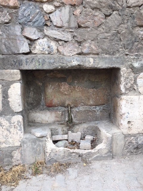
Remains of one of the 40 or so original Seljuk-era fountains along the Sivas-Tokat caravan road
|
©2001-2026, Katharine Branning; All Rights Reserved.