![]()
The Seljuk Han of Anatolia
ROADS IN ANATOLIA
PREHISTORY TO THE SELJUKS
back to the Roads and Routes page
Long before the arrival of the Seljuks in the 12th century, the lands of Anatolia were crisscrossed by important trade routes which ensured a vital commercial trade activity between Asia, the Middle East and Europe. In the beginning, routes were localized mostly in the north-south axis to connect Egypt with Mesopotamia. Later, they developed in the east-west direction across Anatolia as political and commercial relations expanded.
Prior to the arrival of the Seljuks on the scene in Anatolia in the 11th century, there were 5 main road systems built by previous civilizations in the area. These include:
1. Prehistoric (Neolithic Era) roads
2. Assyrian and Hittite roads
3. Persian roads
4. Roman roads
5. Byzantine roads
Prehistoric (Neolithic Era) Routes: Way before silk, there was obsidian…...
Most Anatolian Seljuk hans were built on roads in use since ancient times. Some of these roads date back to the Neolithic Era; in other words, since the dawn of civilization. Anatolia was an important area of human development in the Neolithic Period (10,000-5,500 BC), before the development of metalworking. At this time, tools of flint and obsidian were used to make cultivating tools. The site of Çatal Höyük near Konya was a Neolithic town covering more than 32 acres and is the largest Neolithic era site discovered so far. It was inhabited from 7,000-5,600 BC, and the obsidian obtained from the nearby volcano of Hasan Dağ was used to make the tools that led to this city’s development.
There is substantial evidence that exchange networks already existed in Anatolia before the Neolithic period with goods — especially obsidian — travelling over long distances. By the middle of the third millennium BC, a long distance network of connections between the Anatolian plateau and Upper Mesopotamia had been established, which brought an intense exchange of goods, technologies and ideas. From the second millennium BC onwards, textual evidence has added major contributions to the understanding of routes, the location of trading centers and the details of journeys.
Especially important were the obsidian exchange routes. Obsidian is a naturally occurring volcanic glass, which forms into rock when the lava is suddenly cooled when it comes in contact with water. As it is hard and brittle, it fractures with very sharp edges, and was thus used to make cutting and piercing tools and arrowheads. These little pieces of mountains were brought home by traders throughout the Middle East. Acigöl (a town near Nevşehir) and the Göllu Dağ volcano (near present-day Niğde) were the most important sources in central Anatolia, one of the more important source areas in the prehistoric Near East. Obsidian from these sites has been found in Syria, modern-day Iraqi Kurdistan and western Israel. Another important site for obsidian was Tilkitepe, on the shores of Lake Van, a settlement dating from 5,000 BC. An impressive case displaying these lustrous black tools can be seen in the Museum of Anatolian Civilizations in Ankara, and, to this day, pieces of obsidian can be easily collected while hiking in the hills of the Lake Van region.
Bronze Age Roads of the Assyrian Trade Colonies Period and the Hittite Period: The coin of the realm is tin….
After obsidian, came tin. And, in the beginning, it was all about tin, not silk….
Archaeologists now present evidence that dates the earliest international trade convoys to 2,700 B.C. during the early Bronze Age. In the 2nd Millennium BC, a well-developed trade route between Anatolia and Mesopotamia was used by Assyrian merchants, and the name of the game was metals, and, in particular, tin. Tin was an important commodity, as it was vital ingredient in the production of bronze (bronze is comprised of a mixture of about 10-12% tin and copper). The bronze alloy formulated in the eastern Mediterranean in the 3rd Millennium BC brought about a revolution in economics, civilization and warfare.
As mentioned above, many peoples in the ancient world were attracted to Anatolia, and there are several reasons for this. It was a land of rich raw materials, such as timber and agricultural products of all kinds. The arid, treeless steppe country of central Anatolia today was more forested in ancient times, before goats, timber-hungry humans and neglect took their toll. There was yet another resource that made the land attractive: the abundance of the mineral wealth with which the advance of civilization made increasingly necessary. Man needed metals to make tools and weapons. Anatolia took great economic and political importance in the history of the ancient Middle East due to metals.
Although the prosperity of the Neolithic site of Çatal Höyük near Konya was based on obsidian, the inhabitants of Çatal Höyük were also acquainted with the use of another important local material: copper. Already before 7,000 BC at Çayönü, close to the rich Ergani Maden copper mines near the modern day city of Elaziğ, native copper was being cold-hammered into tools and pins, and there are signs of heat being used in a quenching process. Before 6,000 BC, the local smithies of Çatal Höyük had mastered the technique of smelting, as can be seen in the trinkets found on the site.
The Anatolian mountains were always a principal source of metal for the Mesopotamian world. With the increased importance of metal technology, the north-central and north-western parts of Anatolia, rich in metal deposits, were increasingly developed and settlements there began to grow and prosper in the Chalcolithic era (5,400-3,000 BC), such as Hacilar near Burdur and Acem Höyük near Aksaray. In the latter part of the third millennium BC, Anatolia became a land of small fortified city-states, with their economies based on agriculture, but with their real wealth residing in their metals and metal products. Anatolia was in a commanding position to become a Bronze Age leader around 2,600-2,300 BC, and this importance spread to south Russia and southern Mesopotamia. People wanted to trade in Anatolia’s metals, creating the important period known as the Assyrian Trade Colonies Period (1,950-1,750 BC).
No site offers more evidence of the intense trade activity between Assyria and Anatolia than the famous trade post of Kanesh (Kültepe) near Kayseri. Around 1,940 BC merchants from Assyria were found here. Excavations have proven that Kanesh was a trading post with a quarter filled with merchants’ housing. The large quantities of business correspondence written on clay tablets found here tells the story. And this story is that the Assyrians craved metals. The Assyrians clearly wanted silver, gold and copper, and what they gave in return was woolen cloth, made up into clothing of various types, and a metal which was most probably tin.
The quest for tin formed the backbone of the Anatolian trade routes. Anatolia, although rich in minerals and with plentiful copper mines, was tin-poor. There was not enough local tin to sustain a developing Bronze Age economy (bronze is comprised of a mixture of about 10-12% tin and copper), so it had to be imported. Trade in tin played a considerable part in economic life. But the puzzling question is: where did the Assyrians get the tin they traded In Anatolia?
Around 1,780 BC, for reasons to this day not understood, the Assyrian trade connection with central Anatolia came to an abrupt end. At this time the Hittites (1750-1200 BC) made their appearance, and soon grew into the most powerful empire of the Middle East. From their capital at Boğazköy near modern Yozgat, they led military campaigns to the west, south to Aleppo, and battled with the local dynasties and Pharaonic Egypt for supremacy. Although researchers have learned much about the history of this kingdom, the perplexing question of the tin source remains. Where did this tin, widely used in the manufacture of bronze in ancient Anatolia, come from? There is no clear indication of any source in the area. The tin used in the Mediterranean basin, Anatolia, western Iran and Mesopotamia had to come from somewhere, but where? Such far-flung suggestions have been the desert of Egypt, Thailand and Malaysia, Cornwall, Bohemia, or perhaps a source in Anatolia which was exhausted and thus not known today. In recent years, a new possibility has emerged with the discovery of major tin deposits in Afghanistan.
It is probable that the tin source was indeed Afghanistan. It is believed that the trade of 5,000 years ago involved cargos of tin, brought from the mountains of Afghanistan overland across Iran to the city of Eshnunna (Tel Asmar in current-day Iraq) on the Tigris river in Mesopotamia or overland to Assur in northern Iraq. From there the cargos were transported overland to the city of Mari in eastern Syria and then on to the Mediterranean port of Ugarit (current-day Ras Shamra) in northern Syria near Latakya. There, it was loaded onto donkeys for transport north to the trade networks of Anatolia.
The trade road linking the Upper Mesopotamian region with Anatolia established in the Assyrian Trade colonies period (1950-1750 BC) continued through the Hittite era. Roads developed by the Assyrian merchants originated in upper Mesopotamia and reached Kayseri via Mardin, Diyarbakir and Malatya. They ended at Kültepe near Kayseri, an important Assyrian merchant stop. Much information about the roads and goods exchanged during this important commercial period has been revealed in the store of clay tablets found at Kültepe, one of the world's first cities open to free trade. The route later was extended from Kayseri south to Niğde and north to Sivas. It eventually connected to Persia and was responsible for making Kayseri a leading trading center of the age. This trade nexus was still vital in Seljuk times, when a vast commercial fair called the "Yabanlu Pazari" (Bazaar of the Foreigners) was held forty days a year at a place still called Pazarören near Kayseri. It is referred to by Mevlana in his Mesnevi.
The Persian Royal Road: the Pony Express of its day…
The Lydians (700-300 BC) were the first to rehabilitate the ancient roads of Anatolia. An important road through Anatolia was established in the Lydian period in the 5th century BC by the Persian King Darius I of the Achaemenid Empire: The "Royal Road". This road started from Sardis in the Lydian region of western Anatolia and ended in Susa, the center of the Persian Empire at the time. Sardis, capital of the ancient kingdom of Lydia, was one of the most important cities of the Persian Empire and later the seat of a proconsul of the Roman Empire. This road was built to facilitate communication through the vast empire of Darius. It ran 1,500 miles (2414 km) took almost three months to travel by foot; however, an imperial courier service could cover the distance on horseback in nine days. This road effectively connected the Persian cities of Persepolis and Susa with the Aegean city of Sardis in Turkey. Alexander the Great also used the Royal Road to travel to Persepolis. The famous Greek historian Herodotus of Halicarnassus (5th BC) mentions buildings called “flaktria”, on the Royal Road, and are considered to have been rest stops (menzil) along the way, which may have had structures similar to hans to accommodate passengers. He also states: "There is nothing in the world that travels faster than these Persian couriers - neither snow, nor rain, nor heat, nor darkness of night prevents these couriers from completing their designated stages with utmost speed." This became the model for the Pony Express postal system of the American Far West, and the words of Herodotus became the US Post Office’s motto: “Neither snow, nor rain, nor heat, nor darkness of night prevents these couriers from the swift completion of their appointed rounds.”
The writings of Herodotus, the 5th century BC Greek historian, have allowed scholars to reconstruct the road (Histories 5.52-53). He traveled from Sardis to Susa along this road. From Sardis the road ran eastward through Lydia and Phrygia to the Halys River near Gordium, continuing east to Ancyra (Ankara) and Hattusha, the ancient capital of the Hittites. It then skirted Cappadocia arriving at the northern ford of the Euphrates at Melitene (Malatya). There the road crossed two passes in the rugged Taurus range striking southeast to Amida (Diyarbakir) where an easy ford crossed the Tigris River. Proceeding south along the eastern bank of the Tigris, the road passed below Cudi Dağ at Cizre before arriving at the old Assyrian capital of Nineveh (present-day Mosul, Iraq). At Nineveh the route continued overland southeast to Babylon (present-day Baghdad, Iraq). From there, it is believed that it split in two routes, one leading northwest towards China and the other east to Susa in Persia. This road made Sardis one of the richest cities in the world at the time. It was also the site of one of the Seven Churches of Asia, an ancient synagogue and is mentioned in the Bible's Book of Revelations. Sardis, a political and military base, was also known for its industrial arts, notably the manufacture and dyeing of wool and the production of carpets. After the arrival of the Seljuks, Sardis fell off the major trade routes and lost its importance, although the trade route was maintained by the Seljuks.
Roman Roads: Legionnaires lead the way, commerce follows…..
The Romans conquered the world with their roads. Romans were master road builders and were responsible for some of the finest ever laid in the world. Roadbuilding was an official strategy of their plan of conquest. The Romans built roads and milestones, road surfaces, bridges, imperial road stations and military installations. Roman legionnaires, in their heavy-soled, hobnailed leather military boots called caligae, were able to cover 20 miles a day with a back pack of 70-100 pounds.
During the Roman Empire, roads were enlarged by official decree, and additional routes were created in Anatolia. One of the most important of these Anatolian Roman roads was called the Imperial Road (Via Sebaste), built by command of the Roman emperor Augustus beginning in 6 BC. The road formed a great arc, beginning along the Mediterranean at Perge up north to Lake Burdur before looping over to Konya. The road initially was built to allow Roman military units to quickly move throughout the region, enabling a quick response to attacking mountain tribes. In addition, the road connected the major cities of the region to Mediterranean ports. Thus the Via Sebaste and its tributary roads served both as an important communication and trade network and an important link to the wider Roman world.
Much research has been done on Roman roads, made possible by the use of milestones, many of which still exist, and by the legacy of an extraordinary map known as the Tabula Peutengeriana. All the roads built or used by the Romans were marked on this map, and it gives an invaluable trace of the road network of the Roman Empire. The Romans still believed that the earth was flat, and this map is drawn in accordance. Roads were shown on the map by thin lines connecting cities, and some of their names were written along the lines. A copy of this map was made by a priest in Colmar, France, in 1265, and consisted of 11 sheets. It is now held in the Austrian National Library at the Hofburg Palace in Vienna. The cities of Pompeii and Herculaneum were marked on the map, thus providing a terminus ante quem of 79 A.D., the year these two cities were buried under the ashes of a volcano. The cities on the map are portrayed with small cartoon-like images, but the larger cities, such as Jerusalem, Istanbul, Nicomedia (modern Izmit), Iznik and Ravenna were depicted more significantly. The sea and river routes were shown on the map and the sea routes between coastal towns were also marked. Many of the roads shown on this map, which followed two main east-west routes, were still in use at the time of the Seljuks.
The Roman land surveyor and Latin author Siculus Flaccus states that the Romans classified their roads according to their importance. The most important roads were viae publicae (public roads), which were funded by the state. Of secondary importance were viae militares (military roads), built at the expense of the army, which became public roads. Local roads, or actus, came after this. Finally there were privatei (private roads), built and maintained by the owners. Ancient Roman roads consisted of three layers: a bottom foundation layer (statumen), often of stone (for drainage), a middle layer of somewhat softer material sometimes called the rudus (such as sand or gravel), and a surface, or “metaling”, usually gravel or sometimes paving stones. This top surface often had a curbing on the edge. The total depth of a road would be 3-5 ft. (1-1.5m). Seljuk roads may or may not have used the same building techniques for their roads, but in any case, they learned of the importance of building solid roads.
In the Greek Roman period, Kayseri and Central Anatolia were at the heart of the Roman commercial network. Saint Paul walked along these Anatolian Roman roads, and efforts have been made to analyze the Roman roads through his writings in the Bible. There were four main routes at this time, linking Ephesus to Malatya, Kayseri to Ankara, Kayseri to the Black Sea, and Kayseri to points northeast. Cicero reported that stopping points were to be built approximately 75 km (47 miles) from the military camps known as “castrum” in the Roman period, and that some soldiers were kept especially at strategic points along the roads. These military camps included stables, and were a precursor to the more developed hans of the Seljuk period.
The Anatolian Seljuks continued to use the Roman and Byzantine period roads, and rebuilt many of them. Although the Seljuk Sultans created additional roads, they continued to use the ancient roads and thus saved both time and construction costs.
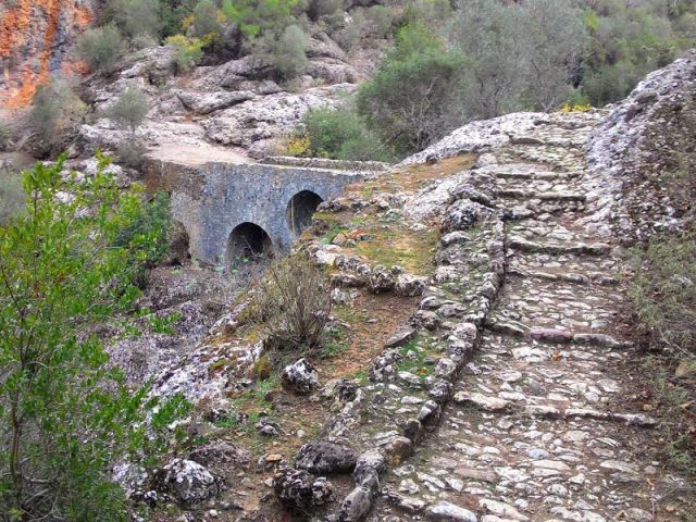 The Roman Ali Bridge near Alanya and its approach road
|
 Roman road near the Ali Bridge
|
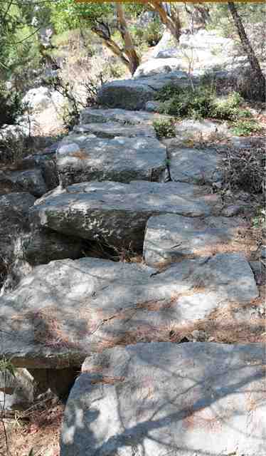
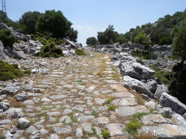
 The Roman Cilician Road in Sağlikli Köy (Mersin Province)
This village is famous for the 3km (1.9 mile) Roman road which starts near the village, and which ends at the south with a gate, which was either an arch gate or a border check point. triumphal gate. The road is thought to be a part of the main road connecting Cilicia to Cappadocia (near Nigde) during antiquity, and was built in the 1st century AD by the Romans. The road is approximately 3 m (9.8ft) wide. This is the only section remaining of the original 148 km (92 mile) road.
|
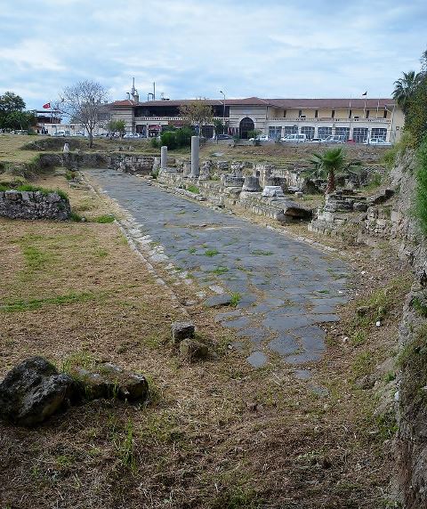 The Roman Cilician Road in Sağlikli Köy (Mersin Province)
A second Roman road, recently discovered, is called the Ancient Road (Antik Yok), is also located in the Tarsus region. Underneath this road is a sewage system, which makes the road unique among the other Anatolian Roman roads. It is not certain if this road was connected to the Sağlikli Köy road.
|
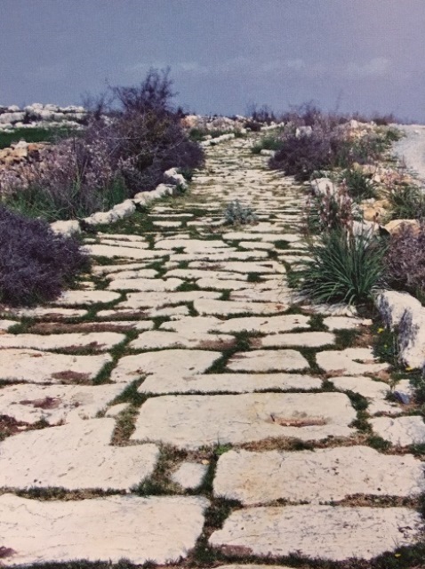
 Via Sebaste |
|
Roads in the Byzantine Period (395-1453): Luxury goods flow to Europe: Anatolian carpets in castles and on church altars; glass in cathedrals
After the founding of Constantinople as the capital of the Eastern Roman and later Byzantine Empires, new overland connections were established with the West through Iconium (later Konya), Sebastia (Sivas) and Tokat to make it possible for caravans to reach the capital city. Üsküdar on the Asian side of the Bosphorus was the terminus of these routes.
However, with the spread of Islam in the Middle East, the Byzantines steadily lost control over the traditional trade routes. They attempted to establish new routes using Black Sea ports, but the main thoroughfares were eventually overcome by the Muslims. Once the Seljuks established themselves in Anatolia, Byzantium completely lost control of the flow of trade through Asia Minor. The Seljuks developed the inland cities of Sivas, Tokat and Niğde to develop trade with Byzantine customers. By erecting hans along the Konya-Kayseri-Sivas route, the Seljuks attracted Genoese commercial interests to Sivas, followed by merchants from Naples, Pisa, and Russia.
In addition, the arrival of the Crusaders in the Middle East increased the volume of trade, as Europeans developed a taste for oriental goods. Pilgrim "Holy Land" souvenirs were highly-prized items. Luxury items such as Islamic carpets, textiles, ivories, metalwork, ceramics and glass filled the stately homes and cathedrals of Europe. Many of these goods passed over the land and maritime routes of Seljuk Anatolia.
©2001-2026, Katharine Branning; All Rights Reserved.