![]()
The Seljuk Han of Anatolia
PASA HAN
A ruined han located along the Sivas-Tokat road, busy since Antiquity.
|
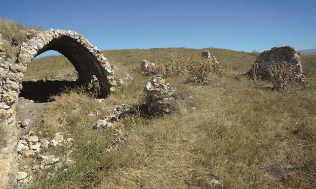
Eravşar, 2017. p. 296; photo I. Dıvarcı |
|
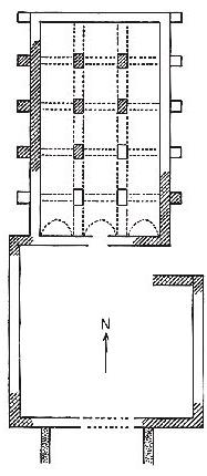
plan drawn by Erdmann |
|
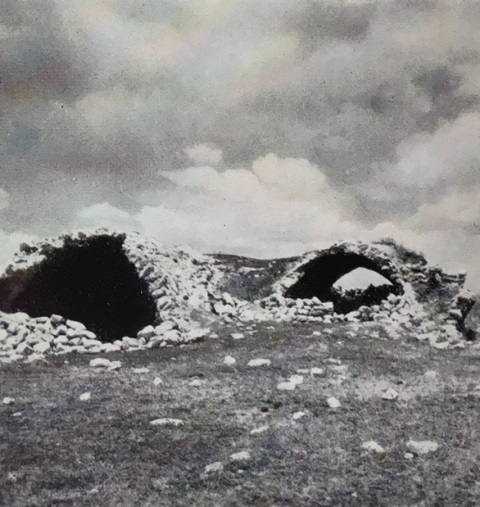
Photo by Erdmann (#113) |
DISTRICT
58 SIVAS
LOCATION
39.848277, 36.955502
The Paşa Han is located 15 km northeast of Sivas on the Sivas-Tokat-Niksar road, along the Tavra River, 100 m. to the right of the road. The modern highway, which is about 100 m from the han, is believed to follow the old caravan route, of which no traces remain. This route was heavily used in the Seljuk era.
NAMES
As the name "pasha" refers to an Ottoman title, it is believed this name was given to the han at a later date, and the original Seljuk name for the han is not known.
DATE
13th century
PATRON
The original inscription plaque has been lost, so it is not possible to determine its patron or construction date.
BUILDING TYPE
Covered section with an open courtyard (COC)
Covered section smaller than courtyard
Covered section with 3 naves
4 lines of support walls parallel to the rear wall
DESCRIPTION
The han, now in ruins, was built on the side of a hill, with the northern side on the higher level. The han is oriented north-south. The plan consists of a covered section and an open courtyard with service areas placed in front of it. The crown doors of the covered section and the courtyard are not on axis. The covered section is slightly smaller than the courtyard.
The covered section comprises three naves with two lines of support vaults which rest on 4 rectangular piers. The ruins indicated that the naves were covered by pointed vaults in the north-south direction. The central nave is higher and wider than the lateral naves. The walls of the han are approximately 1m thick.
There are no traces of the windows, the mosque, exterior towers, spolia material, decoration or inscription. No mason marks can be seen on any of the remaining stones.
It was probably built at the same time as the Çiftlik and Ezinepazaar Hans.
DIMENSIONS
680m2.
STATE OF CONSERVATION, CURRENT USE
The han is, for the most part, in ruins. When Erdmann visited the han, its walls and piers were more solid, but much deterioration has occurred in the last 50 years. The han has been extensively pillaged by scavengers over the years. It is now in ruins, with most of the sections having collapsed into the center of the building, perhaps due to the numerous earthquakes in this area, notably the serious one which shook the region in 1939.
BIBLIOGRAPHIC REFERENCES
Eravşar, Osman. Yollarin Taniklari (Witnesses of the Way), 2017, pp. 296-298.
Erdmann, Kurt. Das Anatolische Karavansaray des 13. Jahrhunderts, 1961, pp. 79-80 no. 23.
Özergin, M. Kemal. “Anadolu’da Selçuklu Kervansarayları”, Tarih Dergisi, XV/20, 1965, pp. 159, n. 94.
©2001-2026, Katharine Branning; All Rights Reserved.