![]()
![]()
The Seljuk Han of Anatolia
MISLER OVASI HAN
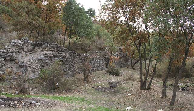
This ruined northern han, located on a Çorum-Samsun road that fell out of service, now lies lost in the middle of a forest.
 Eravşar, 2017. p. 196; photo I. Dıvarcı |
 Eravşar, 2017. p. 199; photo I. Dıvarcı |
 Eravşar, 2017. p. 197 |
DISTRICT
19 ÇORUM
LOCATION
The Misler Ovasi Han is located to the west of Çorum, between Çorum and Boyabat. The caravan route passes from north to south through the valley in front of the han. This route fell out of use in later periods. The roads coming from Çorum intersect at this han and continue towards the west and south. The han is situated within the village of Misler Ovasi today. The han was built on a hillside, inside a forest, on the road to the village of Şendere, about 7km from Misler Ovasi. The han is named after the village in which it is located.
DATE
As there is no inscription, dating of the han or an attribution of a patron is not possible with certitude. However, the han was probably built at the same time as other hans in the region in the first half of the 13th century, at the time when the conquered port of Sinop became the center of the trade in the area.
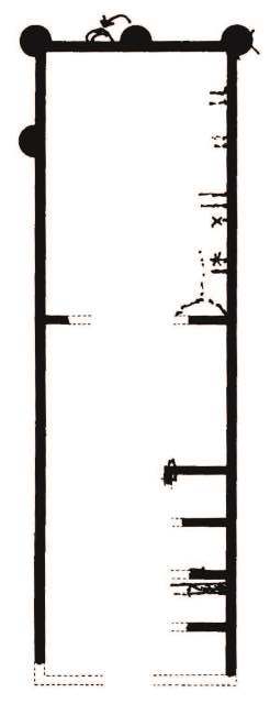
BUILDING TYPE
Covered section with an open
courtyard (COC)
Covered section with middle aisle and 1 aisle on each side
DESCRIPTION
The building has a northwest-southeast axis. This han was built with the classic covered section with open courtyard plan, consisting of a covered section used for lodging and a courtyard with service areas. The han is buried up to the joist level, but the plan could still be determined. Some architectural elements from the outer walls and the covered section are still remaining.
Courtyard: Partition walls belonging to four separate rooms can be seen at regular intervals along the east side of the courtyard service area. A wall separates the covered section from the courtyard. The entrance of the courtyard service area is in the middle of the southwest side, but there is nothing left of the door. The sections in the northwest side of the service area were probably covered with arcades.
Covered section: Traces of equally-spaced support arches can be seen on the east wall of the covered section.
Existing data indicates that the covered section had three naves with two support lines. The central nave is higher than the side naves.
The crown door of the covered section, currently buried under soil, was located in the middle of the southwest side.
Traces of pipes, seen in the northeast corner of the covered section, indicate that water was brought from a nearby spring and that there were water supply installations inside the han.
EXTERIOR
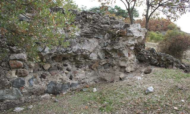
The north and the west sides are currently visible and are reinforced by semi-circular buttresses.
BUILDING MATERIALS
Smooth-cut stones were used in the foundations and corners, while pitch-faced stones were used in the other parts of the building. The outer walls were filled with rubble and mortar.
STATE OF CONSERVATION, CURRENT USE
The han is in ruins. The roof of the han and the walls are damaged for the most part and the interior of the han is filled with soil deposited from the hillside to the south of the han. Numerous pits dug by scavengers can be seen in various areas.
BIBLIOGRAPHIC REFERENCES
Eravşar, Osman. Yollarin Taniklari (Witnesses of the Way), 2017, pp. 196-199.
Eravşar, O. & Yavuz, A.T. & Toprak, G.M. Ortacağda Küzey Anadolu Yollari ve Yol Üstü Kurluşlari. 109K369 Tubitak Projesi Sonuç Raporu, ULAKBIM, 2013, pp. 93-95 and additions.
French, D. Sinop: “The So-called Ceneviz Yolu.” Anatolia and the Ancient Orient Studies in Honor of Tahsin Ozgüç. Ankara, 1989, pp. 143-148.