![]()
The Seljuk Han of Anatolia
ERENKAYA YIKIK HAN
|
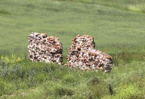
Eravşar, 2017. p. 230; photo I. Dıvarcı |
 |
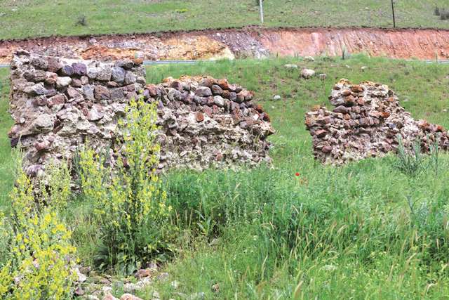 Eravşar, 2017. p. 233; photo I. Dıvarcı |
DISTRICT
42 KONYA
LOCATION
37.746424, 32.126963
The Erenkaya Yikik Han is located on the Konya-Seydişehir caravan route, 44 km from Konya and 4km from the village of Erenkaya. A large section of the Konya-Antalya modern highway, now the new caravan route for busses descending to Alanya, passes over the old route, obliterating all traces of it. This route was a new route developed by the Seljuks to lead southwest from the busy capital of Konya. The han is situated in a valley on the side of a high hill, with the southern section on the higher level and the northern on the lower level.
NAMES
Little is known about this han, other than the information gleaned from the inscription which is attributed to it. Over time, the Ilistra (Hatun Saray) caravan route was preferred over this route, and the Erenkaya Han ceased to serve its role. No travelers have left notations about this han in their journals.
Professor Ali Baş is the first person to have published a study of this han. In his work he named the han as the Erenkaya Yikik Han, by combining the name of the region to “Yikik” (“in ruins”), the name the locals use to refer to the han.
DATE
Beginning of the 13th c. (est)
Alanya was conquered by the Seljuk sultan Alaeddin Keykubad in the last months of 1221. After this date, the Konya-Seydişehir-Alanya route saw heavy traffic. The Alara, Şarapsa and Kargi Hans were built as a result of this development. However, as this is a small han, it may have been built prior to the development of the road. After the conquest, a more substantial building would have been required.
INSCRIPTION
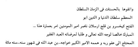
An inscription of 5 lines in Arabic is located over the fountain of the village of Inlice, 5km before the han. Sections of it are broken and parts cannot be deciphered. The beginning of the inscription can, however, be read. It reads as follows:
“Protect your goods by doing favors. This bath (sic) was ordered to be built in the time of the helper of the leaders of the believers, the father of conquests, the owner of the world and religion, the great sultan, Keyhüsrev, son of Kiliçarslan, for the mercy of Allah and in honor of the glory of Allah, by the poor slave Hace, son of the great emir Abdullah... needed to the mercy of Allah and help of Allah. This … ordered to be built… In the months of the year… Six hundred…”
Giyaseddin Keyhüsrev I reigned in two different periods: 1192-1196, and 1205-1211). This fountain could have been erected in either two time frames. Baş believes that as there are no other historical buildings in the region, this fountain was probably built at the same time as the han. However, we do not know of any hans built before 1200 (the Altinapa Han dates from 1202; the Alay Han in the same time frame) so the fountain was probably built during his second reign. It this fountain was built at the same time as this section of the road was developed, this han could be one of the earliest built.
PATRON
1205-1211. According to the inscription of the bath, it was built by the Seljuk Sultan Giyaseddin Keyhüsrev I sometime during his second reign. Bas believes that the han was contemporaneous to the building of this bath.
BUILDING TYPE
Covered section with an open courtyard (COC)
Covered section the same width as the courtyard
Covered section with 3 naves
2 lines of support walls parallel to the rear wall
DESCRIPTION
The has is oriented northeast-southwest. The han is in ruins, but it is possible to determine certain characteristics of the han. A 3.5m wall section remains standing. The han was built with the covered section and open courtyard plan.
Courtyard:
Analysis of the ruins indicates that the han consisted of a covered section and an open courtyard of the same width, and which included service areas.
Covered section:
The covered section was divided into three naves by two lines of support vaults. There were four pointed arches on three square piers in each of the support lines, which continued to the rear wall in the north-south direction. The central nave was covered by a pointed vault. This section was oriented north-south. The inner and outer cladding stones of the walls have been removed over the years. There are no traces of the vaults on the walls.
BUILDING MATERIALS
According to the few remaining wall sections, it can be determined that smooth-faced tufa stones were used in the construction. There are also traces of some reuse spolia materials. The walls, approximately one meter thick, were made using the rubble wall technique, with the outer stones filled in with small stones and pebbles collected from the nearby river, mixed with lime mortar.
DIMENSIONS
16.90 X 36.5m
STATE OF CONSERVATION, CURRENT USE
Both main sections are in ruins, and the han is little more than a pile of rocks. Only the west wall up to the roof level of the presumed covered section remains today. An artificial pond was constructed recently to the north of the han.
BIBLIOGRAPHIC REFERENCES
Baş, Ali. “Bilinmeyen Bir Selçuklu Kervansaray: Yikik Han.” I. Uluslararası Selçuklu Kültür ve Medeniyeti Kongresi Bildirileri I , Vol. I (11- 13 Ekim 2000), Selçuk Üniv. Selçuk Araştırmaları Merkezi Yayını, Konya, 2001, pp. 93-101..
Eravşar, Osman. Yollarin Taniklari (Witnesses of the Way), 2017, pp. 230-233.
Kiepert, R. Karte von Kleinasien, in 24 Blatt bearbeitet, 1902-1916.
©2001-2026, Katharine Branning; All Rights Reserved.